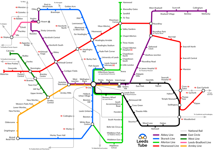
Leeds Tube, v4
Leeds, Politics · · 2 minutesBack in 2013, I created a map of a fictional underground railway: the Leeds Tube.
It was meant to be a provocation; a piece of art that asked the question “what if Leeds had not followed the path of the Motorway City of the 1970s?”
It became so much more than that. It has now been featured in CityMetric, twice in the Yorkshire Evening Post, twice on BBC Radio Leeds, and I regularly hear people talking about it when they are imagining a Leeds with better public transport.
I also still occasionally get feedback about things I missed; areas of Leeds I could have covered better.
For my new blog, I wanted to launch with something special so I’ve brought this map up to a new version for the first time since 2014.
Changes since v3
This new version:
- Changes some of the angles that have been annoying me for years, especially on the East Circle line.
- Renames some things that have changed their names since 2014.
- Extends the West Line out as far as Calverley.
- Extends the Abbey Line out as far as Wetherby.
- Uses Google Fonts Lato and Raleway instead of the proprietary Gill Sans. I don’t have a Mac any more so I needed to do this, but hopefully this makes it more accessible to others too!
Making it your own
This map is released under a Creative Commons Attribution-NonCommercial license, which means you can do whatever you like with it as long as you still credit me and don’t make any money off it.
Download rendered (PNG) Download vector* (SVG)
* Be sure to also get and install the Lato and Raleway fonts if you’re using the SVG.
Purchase a print
If you’d like a copy of the latest version for your wall, you can buy a print of the map from my Society6 store.

